No audio available for this content.
News from the European Space Agency
Galileo’s initial services have been running for more than 15 months now, and signals from the satellites in space are routinely serving users all across the world. The functioning of Galileo is dependent on a global network of ground stations, its current extent shown in the map here.
The constellation in orbit is only one element of the overall satellite navigation system – the tip of the Galileo iceberg. At the same time as satellites were being built, tested and launched, a global ground segment has been put in place, extending to some of the world’s loneliest places, from Svalbard in the High Arctic to storm-engulfed Jan Mayen Island, Ascension Island in the Mid Atlantic to Noumea in the South Pacific, Kerguelen in the southern Indian Ocean to Troll base in the Antarctic interior.
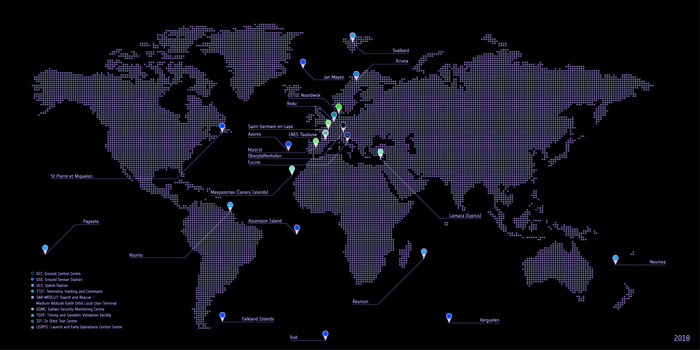
Among the latest developments are updated control and mission software for the two Galileo control centres that sit at the heart of this global web: Fucino in Italy generates the accurate navigation messages that are then broadcast through the navigation payloads, and Oberpfaffenhofen in Germany controls the constellation of satellites. A new telemetry, tracking and command station last year arose in Papeete on Tahiti, in the South Pacific.
Establishing Galileo’s ground segment was among the most complex developments ever undertaken by ESA, having to fulfill strict levels of performance, security and safety. Formal responsibility for the operations of this Galileo ground segment was last year passed to ESA’s partner organization, the European Global Navigation Satellite System Agency, or GSA, but ESA continues to be in charge of its maintenance and growth.

Users don’t have to worry about this ground segment, but it is essential to keeping Galileo services running reliably. The atomic clocks aboard the satellites are accurate to a few nanoseconds, delivering metre-scale positioning precision, but they are prone to drift over time.
Similarly, the orbits of the satellites can be slightly nudged by the gravitational tug of Earth’s slight equatorial bulge and by the Moon and Sun. Even the slight but continuous push of sunlight itself can affect satellites in their orbital paths. The quality of signals received on the ground can be affected by their transit through the ever-changing ionosphere, the electrically active outer layer of Earth’s atmosphere.
Galileo sensor stations, with small omnidirectional receiving antennas around just 50 cm high, are on place around the globe to check the accuracy and signal quality of individual satellites in real time, and work together to pinpoint the current satellite orbits.
These measurements are transmitted via secure satellite communications to Fucino, where they serve as the basis of a set of corrections — accounting for timing or orbital slips — to be uplinked to the satellites via a network of 3-metre-diameter uplink stations for rebroadcast within navigation messages to users, currently updated every 50 minutes.
Considering Galileo is Europe’s largest satellite constellation, timely control of the satellites is essential, enabled by 13 m-diameter telemetry, tracking and command stations in Kiruna, Sweden and Redu, Belgium as well as the equator-hugging Kourou, French Guiana, Reunion, Noumea in New Caledonia and now Papeete sites.

The ground segment also comprises a set of four Medium-Earth Orbit Local User Terminals serving Galileo’s search and rescue service, at the corners of Europe and facilities for testing Galileo service quality and security — the Timing and Geodetic Validation Facility and two Galileo Security Monitoring Centres.
The Launch and Early Operations Control Centres have the task of bringing new satellites to life, to be handed over to the main Satellite Control Centre in Oberpfaffenhofen within typically a week after launch. Redu in Belgium, set up as Galileo’s In-Orbit Test Centre, then puts these satellites through a complex set of testing and checkouts ahead of them joining the working constellation.