
Orbit Data and Resources on Active GNSS Satellites
About These Tables
• GPS World believes this information to be correct. If errors are found, or updates required, please email tcozzens@northcoastmedia.net.
• Dr. Richard Langley of the University of New Brunswick provided the satellite status information and compiled the notes.
Click to download the GPS World Almanac (PDF, August 2018 issue).
| GPS Constellation | GLONASS Constellation | Galileo Constellation | BeiDou Constellation |
|---|
| SBAS Satellites | IRNSS | QZSS | GNSS Internet Resources |
|---|
GPS Constellation
TYPE: Block IIA
| SVN | PRN | CLOCK | LAUNCHED | USABLE | PLANE/SLOT | NOTES |
|---|---|---|---|---|---|---|
| 34 | 18 | Rb | 10-26-93 | 3-20-18 | D6 | A |
TYPE: Block IIR
| SVN | PRN | CLOCK | LAUNCHED | USABLE | PLANE/SLOT | NOTES |
|---|---|---|---|---|---|---|
| 43 | 13 | Rb | 7-23-97 | 1-31-98 | F6 | |
| 46 | 11 | Rb | 10-7-99 | 1-3-00 | D2-F | |
| 51 | 20 | Rb | 5-11-00 | 6-1-00 | E4 | B |
| 44 | 28 | Rb | 7-16-00 | 8-17-00 | B3 | |
| 41 | 14 | Rb | 11-10-00 | 12-10-00 | F2-F | |
| 54 | 18 | 1-30-01 | 2-15-01 | C | ||
| 56 | 16 | Rb | 1-29-03 | 2-18-03 | B1-A | |
| 45 | 21 | Rb | 3-31-03 | 4-12-03 | D3 | |
| 47 | 22 | Rb | 12-21-03 | 1-12-04 | E6 | |
| 59 | 19 | Rb | 3-20-04 | 4-5-04 | C5 | |
| 60 | 23 | Rb | 6-23-04 | 7-9-04 | F4 | |
| 61 | 02 | Rb | 11-6-04 | 11-22-04 | D1 |
TYPE: Block IIR-M
| SVN | PRN | CLOCK | LAUNCHED | USABLE | PLANE/SLOT | NOTES |
|---|---|---|---|---|---|---|
| 53 | 17 | Rb | 9-26-05 | 12-16-05 | C4 | |
| 52 | 31 | Rb | 9-25-06 | 10-12-06 | A2 | |
| 58 | 12 | Rb | 11-17-06 | 12-13-06 | B4 | |
| 55 | 15 | Rb | 10-17-07 | 10-31-07 | F2-A | |
| 57 | 29 | Rb | 12-20-07 | 1-2-08 | C1 | |
| 48 | 07 | Rb | 3-15-08 | 3-24-08 | A4 | |
| 50 | 05 | Rb | 8-17-09 | 8-27-09 | E3 |
TYPE: Block IIF
| SVN | PRN | CLOCK | LAUNCHED | USABLE | PLANE/SLOT | NOTES |
|---|---|---|---|---|---|---|
| 62 | 25 | Rb | 5-28-10 | 8-27-10 | B2 | |
| 63 | 01 | Rb | 7-16-11 | 10-14-11 | D2-A | |
| 65 | 24 | Cs | 10-4-12 | 11-14-12 | A1 | |
| 66 | 27 | Rb | 5-15-13 | 6-21-13 | C2 | |
| 64 | 30 | Rb | 2-21-14 | 5-30-14 | A3 | |
| 67 | 06 | Rb | 5-17-14 | 6-10-14 | D4 | |
| 68 | 09 | Rb | 8-2-14 | 9-17-14 | F3 | |
| 69 | 03 | Rb | 10-29-14 | 12-12-14 | E1 | |
| 71 | 26 | Rb | 3-25-15 | 4-20-15 | B1-F | |
| 72 | 08 | Cs | 7-15-15 | 8-12-15 | C3 | |
| 73 | 10 | Rb | 10-31-15 | 12-9-15 | E2 | XX |
| 70 | 32 | Rb | 2-5-16 | 3-9-16 | F1 | XX |
GPS Notes:
1. “SV Number” refers to space vehicle number. “PRN Number” refers to the satellite’s unique pseudorandom noise code.
2. Clock: Rb = rubidium; Cs = cesium.
3. “Launched” and “Usable” dates are based on Universal Time.
4. The current active GPS constellation consists of 1 Block IIA, 11 Block IIRs, 7 Block IIR-Ms and 12 Block IIFs for a total of 31 satellites and is under FOC (Full Operational Capability). The constellation is in the 24+3 (or “Expandable 24”) configuration with satellites occupying the fore and aft bifuracted slots in the B, D and F planes. There are currently 2 reserve satellites, SVNs, 36 and 38, and one test satellite, 49, near slots, C2, A2 and B1-F, respectively. SVN36 transmitted L-band signals as PRN04 between July 20 and Nov. 28, 2017. SVN38 transmitted L-band signals as PRN04 between May 19 and July 14, 2017. SVN49 transmitted L-band signals as PRN04 again starting Dec. 1, 2017. For these test transmissions, the satellites are not set healthy and not included in broadcast almanacs.
5. The Block IIF-1 through IIF-12 satellites have nicknames Polaris, Sirius, Arcturus, Vega, Canopus, Rigel, Capella, Spica, Deneb, Antares, Altair and Betelgeuse respectively.
6. SVN35 and 36 carry onboard corner-cube reflectors for satellite laser ranging (SLR). SLR tracking of the satellites permitted analysts to differentiate between onboard clock errors and satellite ephemeris errors in GPS tracking.
7. Selective availability (SA) was set to zero on all satellites by presidential order on May 2, 2000 at approximately 4:00 UT. Previous Almanacs provide a history of SA status.
8. Antispoofing (AS) was activated on Jan. 31, 1994, on all Block IIs. AS is occasionally off for testing and other purposes. Previous Almanacs provide a history of AS status.
9. The design life and mean-mission duration goals of the Block IIA, IIR, and IIF satellites are 7.5 and 6 years, 10 and 7.5 years, and 12 and 9.9 years, respectively.
10. The launch of the first Block III (GPS III) satellite is expected no earlier than October 2018.
Performance Notes:
A. SVN34, previously a reserve satellite, was reactivated to replace SVN54. It started to transmit L-band signals as PRN18 on March 8, 2018, and was set usable on March 20, 2018.
B. SVN51/PRN20’s slot designation has been changed from E7 to E4 in GPSOC daily Operational Advisories and on the NavCen website coinciding with the decommissioning of SVN54.
C. SVN54/PRN18 was set unusable on Jan. 23, 2018, and decommissioned from the active constellation on March 5, 2018.
GPS Satellite & System Information
National Executive Committee for Space-Based Positioning, Navigation & Timing
DoD GPS Operations Center and 2SOPS Constellation Status (military only)
U.S. Coast Guard Navigation Center Navigation Information Service (NIS)
GLONASS Constellation
| GLONASS NUMBER | KOSMOS NUMBER | LAUNCHED | USABLE | ALMANAC/ SLOT |
CHANNEL | ORBIT PLANE | NOTES |
|---|---|---|---|---|---|---|---|
| 102 (716) | 2425 | 12-25-06 | 10-12-07 | 15 | 0 | 2 | |
| 103 (717) | 2426 | 12-25-06 | 4-3-07 | 10 | -7 | 2 | |
| 105 (719) | 2432 | 10-26-07 | 11-27-07 | 20 | 2 | 3 | |
| 106 (720) | 2433 | 10-26-07 | 11-25-07 | 19 | 3 | 3 | |
| 107 (721) | 2434 | 12-25-07 | 2-8-08 | 13 | -2 | 2 | |
| 109 (723) | 2436 | 12-25-07 | 1-22-08 | 12 | -1 | 2 | A |
| 116 (730) | 2456 | 12-14-09 | 1-30-10 | 1 | 1 | 1 | |
| 117 (733) | 2457 | 12-14-09 | 1-24-10 | 6 | -4 | 1 | B |
| 118 (734) | 2458 | 12-14-09 | 1-10-10 | 5 | 1 | 1 | |
| 119 (731) | 2459 | 3-1-10 | 3-28-10 | 22 | -3 | 3 | |
| 120 (732) | 2460 | 3-1-10 | 3-28-10 | 23 | 3 | 3 | |
| 121 (735) | 2461 | 3-1-10 | 3-28-10 | 24 | 2 | 3 | |
| 122 (736) | 2464 | 9-2-10 | 10-4-10 | 16 | -1 | 2 | |
| 125 (701) | 2471 | 2-26-11 | (20) | -5 | 3 | C | |
| 126 (742) | 2474 | 10-2-11 | 10-25-11 | 4 | 6 | 1 | |
| 127 (743) | 2475 | 11-4-11 | 3-5-13 | 8 | 6 | 1 | |
| 128 (744) | 2476 | 11-4-11 | 12-8-11 | 3 | 5 | 1 | |
| 129 (745) | 2477 | 11-4-11 | 12-31-11 | 7 | 5 | 1 | |
| 131 (747) | 2485 | 4-26-13 | 7-4-13 | 2 | -4 | 1 | |
| 132 (754) | 2492 | 3-24-14 | 4-13-14 | 18 | -3 | 3 | |
| 133 (755) | 2500 | 6-14-14 | 8-3-14 | 21 | 4 | 3 | |
| 134 (702) | 2501 | 11-30-14 | 2-15-16 | 9 | -2 | 2 | |
| 135 (751) | 2514 | 2-7-16 | 2-28-16 | 17 | 4 | 3 | |
| 136 (753) | 2516 | 5-19-16 | 6-27-16 | 11 | 0 | 2 | |
| 137 (752) | 2522 | 9-22-17 | 10-16-17 | 14 | -7 | 2 | |
| 138 (756) | 2527 | 6-7-18 | 1 | D |
GLONASS Notes:
1. The first GLONASS satellite was launched Oct. 12, 1982.
2. The GLONASS numbering scheme used in this table includes the eight “dummy” satellites orbited as ballast along with “real” satellites on the first seven GLONASS launches. The second number (in parentheses) in the “GLONASS Number” column is that assigned by the Russian Space Forces.
3. The Russian Federation designated the “Kosmos Number.”
4. GLONASS numbers 1–101 have been withdrawn from service.
5. All operational satellites are GLONASS-M satellites, except GLONASS 125 and 134, which are GLONASS-K1 satellites. GLONASS 133 includes an L3 transmitter.
6. All launch and usable dates are based on Moscow Time (Universal Time + 3 hours).
7. Almanac/slot numbers in parentheses indicate the physical orbital slot of reserve/test satellites or those in maintenance and not in the almanac.
8. Channel number “k” indicates L1 and L2 carrier frequencies: L1 = 1,602 + 0.5625 k (MHz); L2 = 1,246 + 0.4375 k (MHz).
9. All GLONASS satellites use cesium atomic clocks.
10. Twenty-four GLONASS satellites are currently set healthy.
11. New GLONASS channel allocations were introduced September 1993 to reduce interference to radio astronomy. Note the use of the same channel on pairs of antipodal satellites.
12. GPS World believes this information to be correct as of press time. However, because of the satellite constellation’s evolving nature, we encourage readers to contact the GLONASS sources listed on these pages for more current information.
Performance Notes:
A. L2 transmissions appear to be impaired.
B. L2 transmissions appear to be impaired.
C. GLONASS 125, the first GLONASS-K1 satellite, is currently in flight test mode near physical orbital slot 20. When not in the active constellation, the satellite typically identifies itself as satellite 26 in its broadcast ephemeris.
D. GLONASS 138 was launched into Plane 1 on June 7, 2018, from the Plesetsk Cosmodrome and is drifting to its intended orbital slot.
GLONASS System Information
The Information and Analysis Center for Positioning, Navigation and Timing (IAC PNT) of the Russian Space Agency publishes official information about GLONASS status and plans as well as consultation, information and scientific-method services to increase GLONASS applications efficiency. It provides current constellations, Earth maps of the current and daily navigation availabilities, results of GNSS navigation field monitoring in the Moscow area in a real-time mode, and other data.
For more information: IAC PNT Center, Central Research Institute for Machine Building, Federal State Unitary Enterprise, www.glonass-iac.ru/en/,email: ianc@glonass-iac.ru
Galileo Constellation
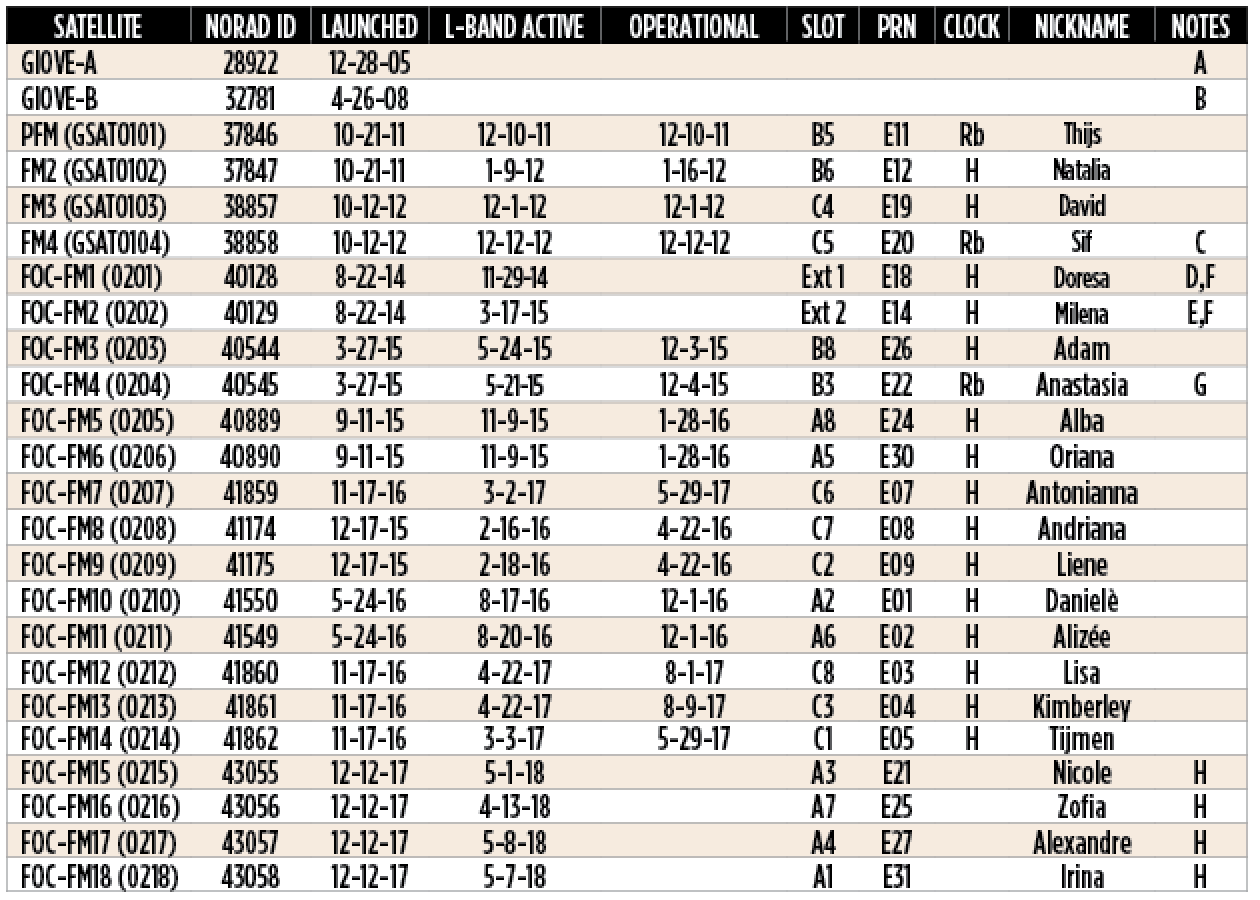
Galileo Notes:
A. Navigation signals from GIOVE-A were switched off on June 30, 2012, and the satellite decommissioned for ESA use.
B. Navigation signals from GIOVE-B were switched off on July 23, 2012, and the satellite decommissioned for ESA use.
C. Payload power problem beginning May 27, 2014. Subsequently transmitted only an E1 signal. Stopped transmitting on July 17, 2018.
D. Orbit perigree raised by about 3500 kilometers in November 2014.
E. Orbit perigree raised by about 3500 kilometers in January–February 2015.
F. Satellites launched into wrong orbits. Testing underway.
G. Transmission outage beginning Dec. 12, 2017, due to constellation management.
H. Undergoing commissioning.
Galileo System Information
Galileo is a joint initiative of the European Commission (EC, ec.europa.eu) and the European Space Agency (ESA, www.esa.int).
The first two full-operational-capability (FOC) satellites, manufactured by OHB Systems GmbH (Bremen, Germany) and Surrey Satellite Technology Ltd. (Guildford, United Kingdom), were launched on Aug. 22, 2014, into wrong orbits due to an upper rocket stage anomaly. Eighteen FOC satellites have been launched to date.
Galileo Initial Open Service was declared operational on Dec. 15, 2016.
BeiDou Constellation
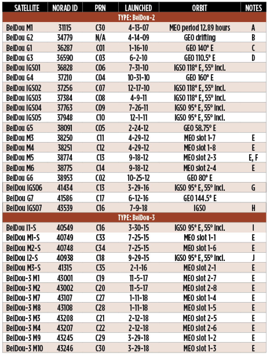
Notes:
IGSO node longitudes are nominal values. Nodes are allowed to drift ±3 degrees or so.
A. Inactive.
B. Initially achieved geostationary orbit at a longitude of about 84.5° E, but appears to have become uncontrollable shortly thereafter. Librating about the 75° E libration point.
C. GEO, formerly at 144.5° E, shifted to 140° E between about June 30 and July 9, 2011.
D. GEO, formerly at 84° E, shifted to 110.5° E between about Nov. 7 and Nov. 23, 2012.
E. The MEO satellites are in a 24-satellite three-orbit-plane Walker constellation with orbit planes spaced by 120° with 55° inclination and orbital period of 12.89 hours.
F. Satellite is not currently transmitting standard signals.
G. Satellite switched PRN from C15 to C13 on Oct. 11, 2016.
H. Commissioning. Drifting to assigned node longitude.
I. PRN switched from C31 to C16 on April 24, 2018.
J. PRN switched from C32 to C18 on June 7, 2018.
Beidou System Information
China fielded a demonstration regional satellite-based navigation system known as BeiDou (Chinese for the “Big Dipper” asterism and pronounced “bay- dough”) following a program of research and development that began in 1980.
The initial constellation of three geostationary Earth orbit (GEO) satellites was completed in 2003. A fourth GEO satellite was launched in 2007.
The initial regional BeiDou system (BeiDou-1) has been replaced by a global system known as BeiDou-2 (or simply BeiDou and, formerly, Compass). It will eventually include five GEO satellites, 27 medium Earth orbit (MEO) satellites, and five inclined geosynchronous orbit (IGSO) satellites.
BeiDou-2 was declared operational for use in China and surrounding areas on Dec. 27, 2011. FOC for this area was declared on Dec. 27, 2012. In March 2015, China began launching test satellites for a global version of BeiDou, called BeiDou-3 and in November 2017, began launching operational BeiDou-3 satellies. These satellites are transmitting test signals. When completed, BeiDou-3 will consist of five GEO satellites, 27 MEO satellites and three IGSO satellites. The system is expected to provide global coverage by 2020.
For more information: Official BeiDou website (English-language version).
SBAS Satellites
| SBAS | SATELLITE | ORBIT LONGITUDE |
PRN | SIGNALS | NOTES |
|---|---|---|---|---|---|
| EGNOS | Inmarsat-3-F2/AOR-E | 15.5° W | 120 | L1 | A |
| Astra 5B | 31.5° E | 123 | L1/L5 | B | |
| Artemis | C | ||||
| Inmarsat-4-F2 | D | ||||
| SES-5 | 5° E | 136 | L1/L5 | E | |
| GAGAN | GSAT-8 | 55° E | 127 | L1/L5 | F, I |
| GSAT-10 | 83° E | 128 | L1/L5 | G, I | |
| GSAT-15 | 93.5° E | 132 | L1/L5 | H, I | |
| GATBP | Inmarsat 4F1/PAC-W | 143.5° E | 122 | L1/L5 | J |
| MSAS | MTSAT-1R | K | |||
| MTSAT-2 | 145° E | 129/137 | L1 | K | |
| NSAS | NigComSat-1R | 42.5° E | 147 | L1/L5 | L |
| QZSS | QZS-1 | 135° E | 183 | M | |
| QZS-2 | 136° E | 184/196 | M, N | ||
| QZS-3 | 127° E | 189/197 | M, N | ||
| QZS-4 | 136° E | 185/200 | M, N | ||
| SDCM | Luch-5A | 167° E | 140 | O | |
| Luch-5B | 16° W | 125 | P | ||
| Luch-5V | 95° E | 141 | Q | ||
| WAAS | Intelsat Galaxy 15 (CRW) | 133° W | 135 | R, T | |
| TeleSat Anik F1R (CRE) | °107.3 W | 138 | S, T | ||
| Inmarsat-4-F3 (AMR) | U | ||||
| Eutelsat 117W B | 117° W | 131 | V | ||
| SES-15 | 129° W | 133 | W |
SBAS Notes:
A. Inmarsat 3-F2 began Safety-of-Life Service on March 2, 2011, and is transmitting message type 2.
B. Astra 5B was launched on March 22, 2014. On March 20, 2017, it became an operational satellite and is transmitting message type 2.
C. Decomissioned for EGNOS use. Satellite sold to Britain’s Avanti Communications.
D. Inmarsat-4-F2 began Safety-of-Life Service on March 22, 2012. It has been retired.
E. SES-5 (also known as Sirius 5 and Astra 4B) was launched on July 9, 2012 and was an operational satellite transmitting message type 2. On March 21, 2017, SES-5 became a test satellite.
F. GSAT-8 was launched on May 20, 2011.
G. GSAT-10 was launched on Sept. 28, 2012.
H. GSAT-15 was launched on Nov. 10, 2015. Its SBAS transponder is in reserve. Transmits test signals.
I. GAGAN was certified for enroute navigation and non-precision approaches on Dec. 30, 2013, and for precision approaches on April 21, 2015.
J. Geoscience Australia Test-Bed Project. Transmitting message type O; not for safety-of-life use. L1 transmissions began on May 31, 2017.
K. MSAS commissioned for aviation use on Sept. 27, 2007. MTSAT-1R has been decommissioned. MTSAT-2 began transmitting both PRN signals on Dec. 10, 2015.
L. Nigerian Satellite Augmentation System. L1 tests.
M. QZS-1 (nicknamed Michibiki) transmits an L1 augmentation signal using PRN code 183. That signal is in test mode. QZS-2 transmits L1 and L5 augmentation signals using PRNs 184 and 196. Central longitudes of satellites can vary by ± 5° or more from nominal value.
N. On June 2, 2018, QZS-3 suffered a signal amplifier switch failure. During trouble shooting, all test signals from QZS-2, QZS-3 and QZS-4 have been temporally halted since June 4, 2018.
O. Luch-5A was launched on Dec. 11, 2011. Initially positioned at 58.5° E, it was shifted to 95° E between about May 30 and June 28, 2012, then shifted to 167° E between about Nov. 30 and Dec. 22, 2012. Transmissions as PRN 140 began on July 12, 2012. Transmitted occasional, non-coherent code/carrier test signals.
P. Luch-5B was launched on Nov. 2, 2012, and started transmitting test signals on Jan. 17, 2013.
Q. Luch-5V was launched on April 28, 2014. Testing may have started using PRN 140, not 141.
R. Galaxy 15 ranging supports enroute through precision approach modes. Switched to backup satellite oscillator on Jan. 6, 2012.
S. Anik F1R ranging supports enroute through precision approach modes.
T. The Galaxy 15 and and Anik F1R payloads, operated by Lockheed Martin for the FAA, are known as LMPRS-1 and LMPRS-2, respectively.
U. As of July 18, 2015, Inmarsat-4-F3 indefinitely discontinued non-precision approach ranging service. The satellite transponder was retired in November 2017.
V. Eutelsat 117W B began service on March 28, 2018, supporting enroute through precision approach modes.
W. SES-15 was launched on May 18, 2017, and began transmitting test signals on Dec. 18, 2017.
IRNSS Constellation
| Satellite | NORAD ID | LAUNCHED | ORBIT | NOTES |
|---|---|---|---|---|
| IRNSS-1A | 39199 | 7-1-13 | IGSO 55° E | A |
| IRNSS-1B | 39635 | 4-4-14 | IGSO 55° E | |
| IRNSS-1C | 40269 | 10-15-14 | GEO 83° E | |
| IRNSS-1D | 40547 | 3-28-15 | IGSO 111.75° E | |
| IRNSS-1E | 41241 | 1-20-16 | IGSO 111.75° E | |
| IRNSS-1F | 41384 | 3-10-16 | GEO 32.5° E | |
| IRNSS-1G | 41469 | 4-28-16 | GEO 129.5° E | |
| IRNSS-1I | 43286 | 4-11-18 | IGSO 55° E | B |
IRNSS Notes:
A. Decommissioned.
B. Commissioning.
According to the Indian Space Research Organisation (ISRO), the Navigation with Indian Constellation (NavIC), also known as the Indian Regional Navigation Satellite System (IRNSS), consists of three GEO satellites located at 32.5°E, 83°E, and 129.5°E as well as two pairs of IGSO satellites with their nodes at longitudes of 55°E and 111.75°E with an orbital inclination of 29°. The satellites transmit signals at 1176.45 and 2492.028 MHz.
All three rubidium atomic clocks on IRNSS-1A have failed. A replacement satellite, IRNSS-1H, was launched on Aug. 31, 2017, but was not successfully deployed. A further replacement satellite, IRNSS-1I, was launched on April 11, 2018.
For more information: ISRO website
QZSS
The Quasi-Zenith Satellite System is operated by the Japan Aerospace Exploration Agency (JAXA). It is a four-satellite regional time-transfer system and satellite-based augmentation system that will be receivable within Japan.
The first IGSO satellite, QZS-1 (named Michibiki), was launched Sept. 11, 2010. The second IGSO satellite, QZS-2 also known as Michbiki No. 2, was launched on June 1, 2017, followed by a GEO satellite on Aug. 19, 2017, and an IGSO satellite (QZS-4, or Michibiki No. 4) on Oct. 9, 2017.
The constellation of three IGSO satellites and one GEO satellite is expected to be operational in 2018.
QZSS transmits six signals compatible with GPS and Galileo signals at the L1, L2, L5 and E6 frequencies, including augmentation signals (see SBAS table).
GNSS Internet Resources
United States and Canada
Canadian Space Geodesy Forum
This University of New Brunswick service presents daily GPS constellation status reports, ionospheric disturbance warnings, and news and discussion about GPS and other space-based positioning systems by way of electronic mail. Downloadable files are also available. To subscribe, email the one-line message [sub CANSPACE your_name] to listserv@UNB.CA.
For more information: Terry Arsenault or Richard Langley, phone (506) 453-4698, fax (506) 453-4943, email se@unb.ca.
The U.S. government provides the GPS.gov website to educate the public about the Global Positioning System and related topics. Information includes content for the general public, for Congress, for international citizens, for professionals, and for students. The site is maintained by the National Coordination Office for Space-Based Positioning, Navigation, and Timing in coordination with multiple federal agencies.
DoD GPS Operations Center and 2SOPS Constellation Status (Military only)
The U.S. Department of Defense (DoD) GPS Operations Center and the 2nd Space Operations Squadron (2SOPS), U.S. Air Force, maintain Internet sites for military and DoD users only; civilians are referred to the U.S. Coast Guard’s Navigation Information Service. The GPS Operations Center provides DOP predictions, GPS performance assessments, anomaly impact analysis, GPS FAQs, and other services to meet the needs of GPS users in the field. 2SOPS operates a GPS Constellation Status site with scheduled outages, user advisories, almanac data, electronic mail, and downloadable files.
For more information: Military: Contact GPS Operations Center at DSN 560-2541 or Commercial (719) 567-2541, https://gps.afspc.af.mil/gpsoc. Civilians: Contact USCG Navigation Center at (703) 313-5900, www.navcen.uscg.gov. Website POC, email: gps@schriever.af.mil.
National Executive Committee (EXCOM) for Space-Based Positioning, Navigation & Timing (PNT)
The EXCOM advises senior national government leadership and coordinates with federal agencies about policy matters concerning GPS, its augmentations, and related systems. The deputy secretaries of Defense and Transportation jointly chair the EXCOM. Executive Committee membership includes equivalent-level officials from NASA, the departments of State, Commerce, Homeland Security, Agriculture, Interior, and the Joint Chiefs of Staff. Components of the Executive Office of the President and other selected agencies participate as observers. The National Coordination Office, an interagency staff directed by a member of the Senior Executive Service in Washington, provides day-to-day administrative and operational support to the EXCOM. The National Space-Based PNT Advisory Board operates in an independent advisory capacity for the EXCOM as directed by the National PNT Policy and in accordance with the Federal Advisory Committee Act.
For information contact: National Coordination Office for Space-Based PNT, Herbert C. Hoover Building, Rm. 2518, 1401 Constitution Ave. NW, Washington, D.C. 20230, phone: 202-482-5809, fax: 202-482-4429, email: pnt.office@gps.gov.
National Geospatial-Intelligence Agency (NGA)
Precise GPS Orbit Information and Earth Orientation Parameter Predictions (EOPP)
The NGA Global Positioning System Division/Ephemeris Support and Analysis Team maintains a World Wide Web page for Department of Defense and civilian users with precise GPS orbit and clock information based on tracking data collected from NGA, U.S. Air Force, and IGS stations. Daily and weekly precise ephemeris and clock estimate data, both center-of-mass (pedata) and antenna phase center (apcpe) are calculated on a 15-minute interval. Approximately two years of data are kept at this site with previous data available on request. NGA also offers a nine-day orbit prediction ephemeris along with a daily orbit and clock “rapid” ephemeris, also calculated on a 15-minute interval. Earth Orientation Parameter Predictions, based on data provided by the U.S. Naval Observatory, are provided. EOP coefficients and predictions, used by the Air Force GPS Operational Control Segment, are calculated each Thursday to go into effect the following Sunday through Saturday (each new GPS week). Daily EOPs are computed for testing and evaluation to be used in GPS III.
For more information: Duty hours (6 a.m.–6 p.m., Mon–Fri): 314-676-9142 or DSN 846-9142, email: gps@nga.mil.
24-hour contact: 314-676-9140 or DSN 846-9140.
Natural Resources Canada, Canadian Spatial Reference System
Natural Resources Canada, Canadian Geodetic Survey, operates the Canadian Active Control System (CACS), a national network of continuously operating GNSS tracking stations. Products derived from CACS include GNSS observation data, precise GNSS orbits, and precise GNSS clock corrections. The system supports the positioning requirements of a broad range of users, including the most demanding post-mission scientific applications, providing coordinates in either the Canadian Spatial Reference System (CSRS) or the International Terrestrial Reference Frame (ITRF). An online Precise Point Positioning (CSRS-PPP) service allows GPS users from around the world to recover accurate positions from a single GNSS receiver by submitting their RINEX observation data via the Internet. Information about access to CACS, data availability, and other geodetic products and services is available 24 hours a day from a free online subscription service (CSRS Online Database).
For more information:Contact our Geodetic Integrated Services unit, 588 Booth Street, Ottawa, Ontario, Canada K1A 0Y7; phone (343) 292-6617; email: nrcan.geodeticinformationservices.rncan@canada.ca.
Scripps Orbit and Permanent Array Center (SOPAC)
GPS Orbits, Real-Time GNSS Data, Coordinate Information, and Data Archive
California Spatial Reference Center (CRSC)
California Real Time Network (CRTN)
The Scripps Institution of Oceanography maintains SOPAC, providing precise orbits and data archiving services for the International GNSS Service. Online applications include SCOUT (a global ITRF2014 coordinates generator), SECTOR (epoch-date ITRF2014 and NAD83 coordinates), Online Map Interface (SOMI) and the GPS Explorer data portal with JPL. SOPAC archives 24-hour RINEX data from about 3,000 continuous GNSS stations from more than 20 scientific networks around the world. SOPAC maintains the CSRC, which provides California’s geodetic framework for scientific, engineering, and geographical information systems. SOPAC operates CRTN for the CSRC, providing NTRIP data streams in RTCM3 format from over 600 hundred stations in the western U.S., available through a subscription service. The 1 Hz RINEX data are archived at SOPAC. email archive@gpsmail.ucsd.edu.
For more information: Contact SOPAC, Scripps Institution of Oceanography, UCSD, IGPP 0225, 9500 Gilman Drive, La Jolla, CA 92093-0225, USA; call (858) 822-2156 or email archive@gpsmail.ucsd.edu.
U.S. Coast Guard Navigation Center
This site offers GPS constellation status, scheduled outage updates, user advisories, and almanac data as well as Differential GPS and Coast Guard Local Notice to Mariners information.
For more information: Contact the NIS Watchstander, 24 hours a day, by phone (703) 313-5900, or email tis-pf-nisws@uscg.mil.
U.S. National Geodetic Survey (NGS) GPS Orbit Information
NOAA’s National Geodetic Survey (NGS) manages a network of Continuously Operating Reference Stations (CORS) that provide GPS data to support three-dimensional positioning, meteorology, space weather, and geophysical applications throughout the United States, its territories, and a few foreign countries. The CORS network is a multi-purpose cooperative endeavor involving more than 200 government, academic. and private organizations. NGS partners contribute more than 1,900 independently owned and operated stations to the CORS network. The primary objective of the CORS Program is to define and maintain the National Spatial Reference System (NSRS). The CORS Program also:
- Provides free access to GPS data from the CORS network sites.
- Establishes coordinates and velocities of CORS stations with respect to the NSRS.
- Enables users to determine centimeter-level positions with respect to the NSRS by simultaneously processing their own GNSS data with data from the CORS network.
- Computes GPS satellite orbits to support post-processing applications.
- Provides web services for post-processing GPS data via its Online Positioning User Service (OPUS).
- Calibrates GPS antenna phase center values.
- Establishes guidelines for operating and using active geodetic control networks.
NGS continually updates its website with new information on the CORS program.
For more information: email: ngs.cors@noaa.gov
U.S. Naval Observatory
The U.S. Naval Observatory (USNO) provides GPS timing data and status information.
For more information: Contact Stephen Mitchell, phone: (202) 762-1455 or DSN 762-1455, email: Stephen.j.mitchell1@navy.mil.
International
International GNSS Service (IGS)
The foundation of IGS is a global network of more than 400 permanent, continuously operating, geodetic-quality GPS and GPS/GLONASS sites. The station data are archived at four global data centers and six regional data centers. Ten analysis centers regularly process the data and contribute products to the analysis center coordinator, who produces the official IGS combined orbit and clock products. Timescale, ionospheric, and tropospheric products are analogously formed by specialized coordinators for each. The IGS reference-frame coordinator determines tracking site coordinates and velocities from analysis centers’ solutions, and organizes the IGS contribution to the International Terrestrial Reference Frame (ITRF). The IGS Central Bureau is responsible for day-to-day management of the IGS, following policies set by the IGS International Governing Board as well as for communication and outreach. More than 200 institutions and organizations in more than 90 countries contribute to the IGS, a service established within the International Association of Geodesy since 1994. The IGS intends to integrate future GNSS signals, such as Galileo, into its activities, as demonstrated by the successful incorporation of GLONASS.
For more information: Contact International GNSS Service Central Bureau, Jet Propulsion Lab MS 238-540, Pasadena, CA 91109 USA; phone (818) 354-2077, fax (818) 393-6686, email: cb@igs.org.
Geoscience Australia applies geoscience to Australia’s most important challenges by providing geoscience information, services and capability to the Australian Government, industry and stakeholders. It is responsible for the development of Australia’s Satellite-Based Augmentation System (SBAS). Geoscience Australia is the national focal point for coordination of geodetic information and data, and maintains a national network of observatories which forms part of a global observatory network. Users can download RINEX data from continuously operating GNSS observatories via a public FTP server (ftp://ftp.ga.gov.au) or connect to GNSS data streams in real-time via the AUSCORS Ntrip Broadcaster (http://auscors.ga.gov.au). Geoscience Australia also provide a number of geodetic calculation tools, a geoid model to convert between ellipsoidal heights and the Australian Height Datum (AUSGeoid) and an online GPS processing service (AUSPOS) which allows users to upload dual-frequency RINEX data and receive computed positions rapidly by email.
For more information: Contact Geoscience Australia, phone +61 (2) 6249 9111, fax +61 (2) 6249 9929, email: geodesy@ga.gov.au
Czech Republic
The Czech Technical University, Faculty of Electrical Engineering, Department of Radio Engineering in Prague, Czech Republic, offers historical constellation status and almanac data for both GPS and GLONASS systems.
For more information: Email service administrator at pavel.puricer@fel.cvut.cz or contact Frantisek Vejrazka, Czech Technical University, Technicka 2, 166 27 Prague 6, Czech Republic; phone: (+420) 2 2435 2246, fax: (+420) 2 3333 9801, email: vejrazka@fel.cvut.cz.
The Danish Agency for Data supply and Efficiency provides GNSS raw carrier-phase data by request. The service is based on the permanent reference station network, operated by the Danish Agency for Data supply and Efficiency (SDFE).
For more information: Contact the Geodetic Office, Danish Agency for Data supply and Efficiency, Rentemestervej 8, DK-2400 Copenhagen NV, Denmark; phone +45 72 54 50 00, email: grf@sdfe.dk.
The Information and Analysis Center for Positioning, Navigation and Timing (IAC PNT) of the State Space Corporation “Roscosmos” publishes official information about GLONASS status and plans as well as consultation, information, and scientific-method services to increase GLONASS applications efficiency. It provides current constellations, Earth maps of the current and daily navigation availabilities, results of GNSS navigation field monitoring in the Moscow area in a real-time mode, and other data.
For more information: IAC PNT Center, Korolyov, Russia, email: ianc@glonass-iac.ru.