
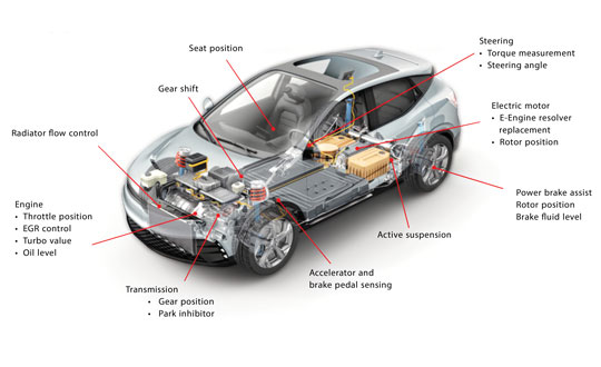
OxTS enhances autonomous vehicle validation solution
March 14, 2024
OxTS’ GNSS-aided inertial navigation systems (INS) are now supported on the NVIDIA DRIVE autonomous vehicle development platform.
Read More
OxTS’ GNSS-aided inertial navigation systems (INS) are now supported on the NVIDIA DRIVE autonomous vehicle development platform.

On Jan.11, speaking at a press briefing in Paris, Javier Benedicto, director of navigation for the ESA, announced the agency had completed the procurement process for the low-Earth Orbit Positioning Navigation and Timing (LEO PNT) program.

Laser leveling has been increasingly replaced by machine control systems that enable operators to compare the position of their machine’s blade with a digital grading map, and then guide it very precisely to cut the proper elevation.
Microchip makes an integrated circuit, known as an inductive position sensor, that is very well suited for machine control because it is not affected by the harsh conditions on most construction sites.

The European Organization for the Safety of Air Navigation (EuroControl) has awarded GMV a contract for the evolution of AUGUR, a free service for pilots, airspace users and air navigation service providers.

Geely, a Chinese automaker, has launched its second set of low-Earth orbit (LEO) satellites in its effort to enhance navigation capabilities for autonomous vehicles.

Intecs, a hardware and software developer, is creating a multi-sensor, GNSS-based platform for obtaining absolute position of trains on rail lines.

Every day, the FAA monitors and assists more than 45,000 flights — up to 5,000 at any one time — across the more than 29 million square miles that make up the U.S. National Airspace System (NAS).


Follow Us