
OxTS introduces GNSS/IMU
January 17, 2024
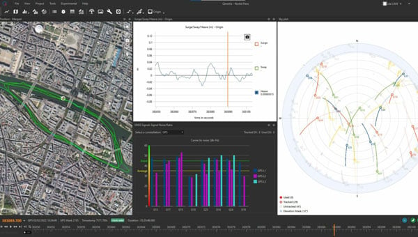
OxTS has introduced the RT3000 v4 GNSS inertial measurement unit (IMU) which combines two survey-grade GNSS receivers with OxTS’ latest IMU10 inertial technology.
Read More
OxTS has introduced the RT3000 v4 GNSS inertial measurement unit (IMU) which combines two survey-grade GNSS receivers with OxTS’ latest IMU10 inertial technology.

A series of powerful earthquakes hit western Japan on Jan. 1, killing at least 55 people and damaging thousands of buildings, vehicles and boats, reported CNN. Japanese officials warn that more earthquakes could lie ahead.
A roundup of recent products in the GNSS and inertial positioning industry from the December 2023 issue of […]

Inertial Labs and BayesMap have partnered to release PCMasterPro software updates for Inertial Labs’ Resepi.

NGS has announced that users have until February 29, 2024, to submit data for the initial National Spatial Reference System (NSRS) modernization rollout.

The United States Geological Survey (USGS) and Dewberry, a privately held professional services firm, have jointly released a […]

Deep Sand Technology (DST) and the GEODNET Foundation have partnered to bring precision agriculture real-time kinematic (RTK) services to rural North America.

Topodrone has launched the PT61 camera, a thermal mapping solution designed for UAVs. The camera system aims to provide users with detailed thermal orthomosaic maps and accurate 3D models.


Follow Us