
Pix4D offers RTK rover for iOS devices
March 8, 2022
Pix4D is now offering a real-time kinematic (RTK) rover for use with iOS devices. The Pix4D viDoc RTK […]
Read More
Pix4D is now offering a real-time kinematic (RTK) rover for use with iOS devices. The Pix4D viDoc RTK […]

Skyward, a Verizon company, has announced its integration with Pix4D, a photogrammetry software suite for drone mapping. The […]
Skyward, a Verizon company, has announced its integration with Pix4D, a photogrammetry software suite for drone mapping. The partnership gives […]
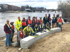
The U.S. Geological Survey (USGS) and independent scientists gathered this month in Auburn, Maine, to evaluate the use […]

Pix4D has announced Pix4Dfields, its first fully dedicated product for agriculture. A beta program to test the software […]

Professional drone company Wingtra is partnering with photogrammetry company Pix4D. Pix4D’s software suite is now available to WingtraOne users, both directly and […]
The ancient city-kingdom of Kourion on the southwestern coast of Cyprus can now be “seen” by those with […]
https://www.youtube.com/watch?v=Ed1JnNccx_s Lorenzo Martelletta of PIX4D gives an overview of the company’s Pix4D image processing software while at INTERGEO […]


Follow Us