2013 Leadership Awards: The Honorees Speak


The GPS World 2013 Leadership Awards.
This article reproduces the acceptance speeches given by the winners of GPS World’s 2013 Leadership Awards, at the Leadership Dinner in Nashville in September.
The Leadership Dinner was sponsored by Lockheed Martin and Exelis.
Nominations for the 2013 Leadership Awards came from the Editorial Advisory Board of GPS World, from the 2012 Award winners, and from a select handful of industry executives. A similar group of GNSS community members, roughly double in size, voted for the final Award winners presented here.
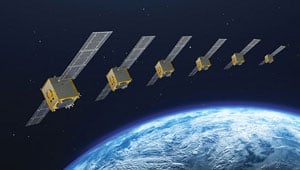
Success with a New System, QZSS
Japanese Government Approves a Four-Satellite Constellation
 It is my great honor to receive this GPS World Leadership Award 2013 on behalf of my team. I’d like to express my gratitude to my family, my colleagues, and especially my team members. We jointly developed the first satellite of the Quasi-Zenith Satellite System in Japan.
The project was established after long discussion between the Japanese government, industries, and user communities, as well as other GNSS providers. QZSS is now providing GPS availability and capability enhancement to Asia and the Oceania region as a regional augmentation system. We are very proud of a great achievement on the first satellite technical validation. Our first satellite can provide the same signal-in-space user range error performance as the latest GPS Block IIR-M and IIF space vehicles.
As a result, considering our achievement, the Japanese government has decided to proceed with the QZSS program to the second phase. So we will have three additional satellites by 2017 and we’ll start the augmentation service surrounding Japan, East Asia, and the Pacific region from 2018, using the four-satellite constellation.
The Japanese government is conducting the system design for the operational QZSS, and the Japanese Aerospace Exploration Agency is continually supporting the government’s activity. We expect that QZSS will bring great social benefits to life in the Asia-Pacific region in a wide variety of fields.
Again, on behalf of all the people who have been involved in the QZSS project, I give my sincere appreciation for this reward. I would also like to acknowledge everybody in this room, because we have learned so many things from this wonderful society. So it is my great pleasure to share my gratitude with you. Thank you very much.
The One Constant: New Challenges
Jamming, Spoofing, Squeezing, Security, and More
 First and foremost, thank you for this wonderful award. It caused me to reflect on all of the wonderful people that I have worked with over the years. This morning, I tried to list these people for NDGPS, WAAS, and APNT; and the lists were too long to repeat in five minutes. For WAAS alone, the list includes people from the Federal Aviation Administration, Stanford University, AJ Systems, RTCA, Raytheon, Zeta, Inc., and the Mitre Corporation. This beautiful award reflects on the efforts of everyone on these long lists.
These lists also remind me of the remarkable community that is GNSS today — all of us. Apparently, we still have our work cut out for us. After all, I understand from this very conference that:
- GNSS is blocked;
- GNSS is jammed;
- GNSS spectrum will be squeezed;
- GNSS is spoofed;
- GNSS is scintillated;
- GNSS is too expensive;
- GNSS is Swiss cheese (thank you, Nunzio).
Honestly, I was not really aware that GNSS is all that fragile. It seems to work fine to me. But let us take the point: these threats are worth our worry, and mitigation will require the full strength of our far-flung community.
Spoofing is worth some special mention. It is certainly interesting, and the theory will be gorgeous. However, I remind you of Faflick’s theorem:
“In your professional life, you will work on many interesting projects. With luck, you will work on some important projects; those will be important to your company, your nation to the global community. However, (Faflick asserts) you will never ever work on any projects that are both interesting and important.”
Well, it seems that GNSS and WAAS are exceptions. But two such small exceptions should not cause us to turn our back on a theorem as powerful or persuasive as the one provided by Faflick. If we apply the theorem, then spoofing cannot be important, because it is interesting. However, I think spoofing is also an exception to Faflick’s theorem.
After all, today’s e-security is based on three security factors: what we know (passwords), what we carry (key fob), and what we are (fingerprints, iris scan). And it is not enough. For example, our health records will soon be online, and the damage caused by losing control of these health records would be great. To meet this challenge, we need to rejuvenate the original security factor: location. In the past, transactions were secured by our presence. In the world of e-commerce, this factor has disappeared, and we must use GNSS to approximate this ancient and effective security factor.
All of this will require the best effort of this precious community of ours.
Science Powers New Applications
Radio Occultation Techniques May Warn of Natural Disasters
 I am deeply honored to receive GPS World’s GNSS Leadership Award this year. Many thanks to the magazine and the international group of GNSS experts for recognizing my contributions to the GNSS community with this prestigious distinction.
I have been privileged to receive support and guidance from a great number of colleagues and friends over the years — too many to list, but I thank them all. If I am a good researcher, it is because I had excellent mentors. Chief among them is Professor Richard Langley of the University of New Brunswick, sitting in the audience, who believed in me and taught me to leave no stones unturned in my research and to continue questioning myself along the way.
Professors George Born and Penina Axelrad also had immeasurable influence on me at the University of Colorado in becoming a GNSS researcher. I am greatly indebted to Tony Mannucci and Brian Wilson at NASA’s Jet Propulsion Laboratory for creating a stimulating, conducive, and rewarding research environment in my group at JPL. I would like to thank my wife Katie and sons David and Adam who have been most patient and who have supported me all these years.
At the early stages of my career, working with GPS data at the University of New Brunswick, we routinely had access to about 40–50 GPS receivers worldwide, and this was after a laborious process of hunting down individual RINEX files. Now, we process data from about 1,200 GPS and GLONASS stations daily in an automated fashion including daily, hourly, and streaming GPS sites. Data centers including ours at JPL generate real-time products to retrieve three-dimensional electron densities using global assimilative ionospheric modeling and other techniques. As computational power increases, I envision that we will see new scientific discoveries evolving with real-life applications and tangible benefits to society. These emerging applications already include the detection of small perturbations in the ionosphere using GNSS real-time measurements that may be indicative of natural hazards generating acoustic and gravity waves in the atmosphere.
Why is this important to us, other than being of scientific interest?
The advances in GNSS ionospheric measurements may soon be capable of augmenting tsunami early-warning systems, for instance. Other potential applications include detecting volcanic eruptions in remote corners of our planet using GNSS data. Less innocent yet equally important may be detecting nuclear tests using GNSS ionospheric measurements.
Another scientific application in the works is the creation of three-dimensional coupled ocean-atmosphere-ionosphere modeling capabilities. These models are at the initial phases of development, running on supercomputers including one at JPL. In a few years, we expect to see that coupled physics-based modeling will help detect and confirm natural hazards and artificial explosions on the Earth’s surface.
In a not too distant future, I anticipate that we will see natural hazard-generated signatures detected using low-Earth orbiting satellites. Initial results suggest that some of the largest events including large earthquakes, tsunamis, and meteor events may be detected in radio occultation measurements. I expect to see a fleet of low-Earth orbiters monitoring Earth’s ionosphere in real time, looking for signatures of tsunamis, earthquakes, volcanic eruptions, meteor events, large forest fires, or nuclear tests.
It is also tempting to use this technology and associated algorithms to claim ionospheric precursors of earthquakes. While I am not convinced about the technical feasibility of ionospheric earthquake precursors, it is a fascinating research area, which has generated heated debates in the community over the years.
With the abundance of different constellations including GPS, GLONASS, BeiDou, QZSS, and others using ground and space-based observations, we are clearly entering a new era when mid-ocean 10-centimeter-level tsunami waves may be detected in the ionosphere at 400 kilometers altitude in real time! Could you have imaged even only 10 years ago that by looking at real-time ionospheric measurements we could infer 10-centimeter-level tsunami waves well before they reach a shoreline? This might help decision makers to save human lives and potentially billions in material damages.
In closing, let me repeat that I am deeply honored to have received the GPS World Leadership Award. I look forward to continue pushing the boundaries of scientific and technical discoveries using GNSS technologies.
Thank you very much.
Getting to the Plus in GNSS
Multi-Constellation, Environments, Multi-Sensors
 Dear friends, dear colleagues, it is with pride that I receive this award tonight, in this very town where I attended ION GPS for the first time in 1998, and where I met some of you for the very first time.
Septentrio didn’t formally exist then, but while at the Interuniversity Microelectronics Center IMEC in Belgium, and just returning from a four-year assignment in the United States, where I witnessed the beginning of civil GPS, I was preparing the creation of the company that I am so proud of, and that is first and foremost a very international family of unique, talented people that I enjoy working with every day!
Hence, my first words of gratitude go to my world-class team that for 15 years now has been at the forefront of advanced GNSS receiver development.
I also take the opportunity to thank some of our long-standing customers and partners, who all those years have given us their business and confidence. In particular, let me thank here tonight the European Space Agency, with whom we have worked hand in hand for more than 10 years. Thank you for your confidence and business — it is a tremendous honor to work with you, and we have enjoyed the truly historic milestones on the Galileo program as much as you have.
As the motivation for tonight’s award, a number of important new developments were mentioned, as achieved by Septentrio throughout an already very busy year:
- the successful position/velocity/time (PVT) calculation using BeiDou satellites in a three-constellation solution on a commercial PolaRx4 platform just days following the official release of BeiDou’s Interface Control Document;
- the first autonomous real-time Galileo PVT calculation. The standalone position was calculated from in-orbit navigation messages using a standard PolaRx4 GNSS receiver equipped with commercially released firmware;
- the first four-constellation PVT performed by a standard commercial receiver. The 3D-position fix happened shortly after the Galileo IOV satellites began transmitting, for the first time ever, a fully usable navigation message as part of an ESA experiment;
- and last, but certainly not least, the first Galileo PRS-only positioning for European Secured Navigation using only the encrypted Galileo Public Regulated Service (PRS) signals broadcast by the four Galileo In-Orbit Validation satellites.
I’ll share with you some future directions for us, outlining three major themes running across our developments.
When we first met here 15 years ago, the focus of our industry was all about GPS. Today, our favorite yearly rendezvous has been rightly renamed ION GNSS PLUS. GPS is not alone anymore. Not alone, because who today would give up the great signal availability that multi-constellation reception brings us? Not alone, because who would claim that GPS can survive in its own bubble of safety without considering the environmental conditions it lives in?
Finally, not alone because modern positioning and navigation require multi-sensor fusion to perform at their best.
Multi-Constellation Reception. Septentrio has, from its very beginning, focused on developing multi-frequency, multi-constellation receivers, at a time when this was far from common. Our first proprietary ASIC was a highly integrated GPS-GLONASS-SBAS chip, which we used as the core of the first generation of Septentrio multi-system/multi-frequency receivers.
“All the signals in the sky” was, is, and will always remain one of our key leitmotifs. We follow with great interest the new developments around the world, for instance for future-generation EGNOS and Galileo systems. As a practical example, I’d like to mention the work that we conduct with European partners on EGNOSv3.
Also, it’s my pleasure to announce here tonight the development of our fourth-generation correlator ASIC, GReCo4: all–in-view, all-signals, all-Septentrio!
The consistent focus on multi-system, multi-frequency receivers was obviously driven by the desire to make very powerful, robust GNSS receivers that would provide high-precision PVTs under the widest range of circumstances.
Our unwavering support for Galileo from the early days was also based on the fact that we could, at the turn of the century, easily receive 15–20 satellites: GPS+GLONASS+EGNOS.
Environments. Obviously, no matter how many independent systems are combined, GNSS remains vulnerable and sensitive to all kinds of interfering sources, human-made and made by Mother Nature. That’s why in recent years, we have been investing a lot of effort in understanding and mitigating the environmental disturbance that affects GNSS receivers.
While we must be humble for, and cannot (completely) tame the forces of Mother Nature, Septentrio has spent a lot of effort on ionospherical receivers. These developments have been conducted by a Septentrio-led consortium of European and Brazilian partners, with as a tangible outcome the Septentrio PolaRxS receiver, aimed at measuring the ionosphere. This unique state-of-the-art receiver is being deployed worldwide by our customers and partners, which helps us improve our understanding of ionopheric behaviour and its impact on GNSS receivers. Our goal: making the most robust professional receivers in the world.
With respect to interference, both intentional and unintentional, Septentrio will continue to improve and expand its solutions. Septentrio’s state-of-the-art Advanced Interference Mitigation (AIM) is AIMed at providing our customers the most robust reception under adverse and hostile conditions.
Multi-Sensors. “All of the signals in the sky” only works if your receiver sees the sky. If there are no satellite signals — for instance, because of blockage of the signals in a container terminal — one obviously needs other sensors to take over and guarantee the continued availability of a PVT-solution.
For several years, we have been offering combined GNSS-INS solutions for a variety of applications, such as management of container terminals. One of our very first customers was the Port of Singapore Authority.
Septentrio will continue to work along these three exciting axes. We look forward to communicating new trends and developments to you wonderful, global GNSS+ community!


Subscribe to GPS World
If you enjoyed this article, subscribe to GPS World to receive more articles just like it.


Follow Us